


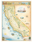

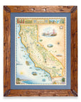
California State Hand-Drawn Map
Travel the length of the Golden State with this 18" × 24" unframed fine art lithograph, featuring an original hand-illustrated map of California by Xplorer Maps Co-Founder and artist Chris Robitaille.
Created in pen and ink with watercolor, this richly detailed artwork captures California's incredible diversity—from towering redwood forests and rugged Pacific coastlines to fertile wine country, soaring Sierra Nevada peaks, and iconic desert landscapes. Every illustration invites you to explore one of the world's most celebrated travel destinations.
The map features many of California's most recognizable landmarks, including the Golden Gate Bridge, Yosemite National Park, Sequoia National Park, Redwood National and State Parks, Lake Tahoe, Napa Valley, Big Sur, Death Valley National Park, Joshua Tree National Park, Los Angeles, San Diego, and the scenic Pacific Coast. Native wildlife, marine life, vineyards, towering sequoias, and historic landmarks add depth and character throughout the artwork.
Whether you've road-tripped along Highway 1, explored the national parks, surfed the coast, or simply love the beauty of California, this museum-quality lithograph makes a timeless addition to any home or office.
Product Details
- Dimensions: 18" × 24"
- Orientation: Vertical
- Print Type: Fine art lithograph
- Artwork by: Chris Robitaille, Co-Founder & Artist, Xplorer Maps
- Printed in the USA
- Ships rolled in a protective tube
SEE THE SPACES SHOWCASING THIS PRODUCT


Disclaimer: When you shop from this page, From Where and the property may earn a commission. Clicking a product link means you agree to our Terms of Use and Privacy Policy.
