


Chesapeake Bay Hand-Drawn Map
-
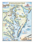
Set sail through the history, wildlife, and waterways of Chesapeake Bay with this 18" × 24" unframed fine art lithograph, featuring an original hand-illustrated map by Xplorer Maps Co-Founder and artist Chris Robitaille.
Created in pen and ink with watercolor, this richly detailed artwork captures the largest estuary in the United States. Stretching across Maryland and Virginia, Chesapeake Bay is renowned for its working waterfronts, historic towns, iconic lighthouses, abundant wildlife, and centuries-old maritime traditions.
The map highlights many of the region's most celebrated destinations, including Annapolis, Baltimore, St. Michaels, Tangier Island, Smith Island, Solomons Island, Cape Charles, and the Chesapeake Bay Bridge. Sailboats, skipjacks, blue crabs, oysters, herons, bald eagles, dolphins, and whales bring the bay's rich ecosystem and nautical heritage vividly to life.
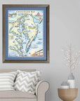
Whether you've spent summers sailing the bay, fishing its waters, exploring charming waterfront communities, or simply appreciate the beauty of the Mid-Atlantic coast, this museum-quality lithograph makes a timeless addition to any home, beach house, or office.
Product Details
- Dimensions: 18" × 24"
- Orientation: Vertical
- Print Type: Fine art lithograph
- Artwork by: Chris Robitaille, Co-Founder & Artist, Xplorer Maps
- Printed in the USA
- Ships rolled in a protective tube
Dimensions: 18” × 24”
-
Orientation: Vertical
-
Print Type: Fine art lithograph
-
Artwork by: Chris Robitaille, Co-Founder of Xplorer Maps
-
Ships: Rolled in protective tube
SEE THE SPACES SHOWCASING THIS PRODUCT


Disclaimer: When you shop from this page, From Where and the property may earn a commission. Clicking a product link means you agree to our Terms of Use and Privacy Policy.
