


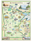
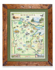
Minnesota State Hand-Drawn Map
Bring the beauty of the North Star State into your home with this 18" × 24" hand-drawn lithographic map of Minnesota by Xplorer Maps. Created in pen and ink with watercolor by Xplorer Maps Co-Founder Chris Robitaille, this original illustration celebrates Minnesota's thousands of lakes, Boundary Waters Canoe Area Wilderness, Voyageurs National Park, Lake Superior's North Shore, scenic waterfalls, forests, wildlife, and the Twin Cities.
Every detail reflects the landscapes, waterways, and outdoor adventures that make Minnesota one of America's premier destinations for paddling, fishing, hiking, and exploring. Whether displayed in a home, cabin, office, or lake house, this fine art print is both a conversation piece and a lasting keepsake.
Product Details
- Dimensions: 18" × 24"
- Orientation: Vertical
- Fine art lithographic print
- Unframed
- Artwork by Chris Robitaille
- Ships rolled in a protective tube
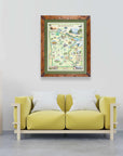
SEE THE SPACES SHOWCASING THIS PRODUCT


Disclaimer: When you shop from this page, From Where and the property may earn a commission. Clicking a product link means you agree to our Terms of Use and Privacy Policy.
