


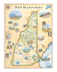
New Hampshire State Hand-Drawn Map
Bring the beauty of the Granite State into your home with this 18" × 24" hand-drawn lithographic map of New Hampshire by Xplorer Maps. Created in pen and ink with watercolor by Xplorer Maps Co-Founder Chris Robitaille, this original illustration celebrates Mount Washington, the White Mountains, Franconia Notch, covered bridges, waterfalls, scenic lakes, wildlife, historic towns, and New Hampshire's charming Atlantic coast.
Every detail reflects the landscapes, history, and outdoor adventures that make New Hampshire one of New England's most treasured destinations. Whether displayed in a home, cabin, office, or mountain retreat, this fine art print is both a conversation piece and a lasting keepsake.
Product Details
- Dimensions: 18" × 24"
- Orientation: Vertical
- Fine art lithographic print
- Original artwork by Chris Robitaille
- Ships rolled in a protective tube
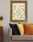
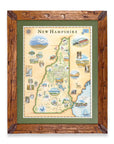
SEE THE SPACES SHOWCASING THIS PRODUCT


Disclaimer: When you shop from this page, From Where and the property may earn a commission. Clicking a product link means you agree to our Terms of Use and Privacy Policy.
