


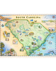
South Carolina State Hand-Drawn Map
South Carolina State Hand-Drawn Story Map – 18” x 24”
Founded in 1670 as one of the original 13 colonies, South Carolina carries centuries of American history in its landscapes — from Revolutionary battlefields to the cobblestone streets of Charleston. This hand-illustrated story map captures the spirit of the Palmetto State, blending its coastal beauty, cultural depth, and natural wonder into a detailed work of art.
Charleston anchors the coast with its historic architecture and vibrant arts scene, while Myrtle Beach and Hilton Head reflect the state’s beloved shoreline and maritime heritage. Inland, Congaree National Park rises with some of the tallest trees in the eastern United States, showcasing South Carolina’s rich biodiversity and wild spaces.
From sweeping palmetto groves to iconic cities and waterways, this map thoughtfully weaves together the state’s defining landmarks and ecosystems.
This fine art lithograph by Chris Robitaille measures 24” x 18” (unframed) and is printed with exceptional clarity and detail.
SEE THE SPACES SHOWCASING THIS PRODUCT


Disclaimer: When you shop from this page, From Where and the property may earn a commission. Clicking a product link means you agree to our Terms of Use and Privacy Policy.
